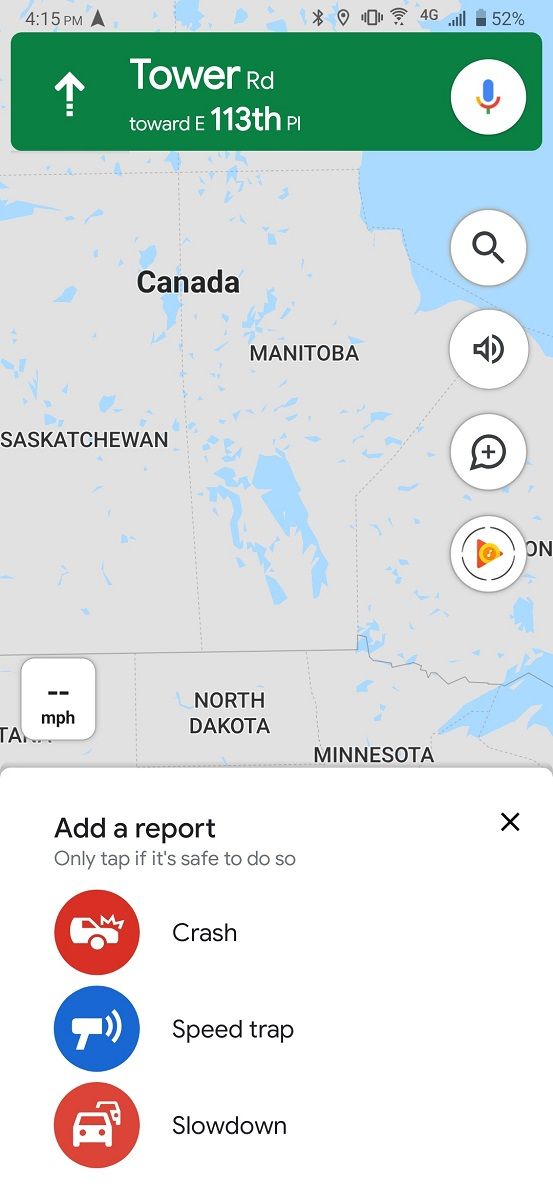
Google Maps is used by millions of drivers, so it’s immensely useful as a crowd-sourced traffic and incident reporting tool. Maps first introduced incident reporting last year, though Waze has had it for years. Google started out with crash and speed trap reporting in November of last year before adding traffic slowdown reporting a few months ago. Earlier today, AndroidPolice noted that road construction reporting was rolling out for some users, which we can also independently confirm. However, we also have evidence that Google is testing at least 3 additional types of incident reports: disabled vehicles, lane closures, and objects on roads.
If you open the Google Maps app, enter navigation mode, and tap on the + icon surrounded by a bubble, you’ll see a bottom sheet with options to report an incident on the road. For most users, including myself, you’ll only have the option to report crashes, speed traps, or slowdowns on the road.
We obtained an unreleased build of Google Maps, version 10.25.24, and it contains new strings that suggest this bottom sheet will be populated with options to report disabled vehicles, lane closures, or objects on the road. The APK also has strings for reporting speed cameras, but these strings already existed in public releases of the Maps app for the past several months. The ability to report speed cameras has yet to appear in the Maps app, so we decided it was worth mentioning too.
Added in version 10.25.24:
<string name="REPORT_INCIDENT_PROMPT_LANE_CLOSURE">Lane closure</string>
<string name="REPORT_INCIDENT_PROMPT_LANE_CLOSURE_REPORTED">Lane closure added to the map</string>
<string name="REPORT_INCIDENT_PROMPT_LANE_CLOSURE_REPORTING">Adding lane closure to the map</string>
<string name="REPORT_INCIDENT_PROMPT_OBJECT_ON_ROAD">Object on road</string>
<string name="REPORT_INCIDENT_PROMPT_OBJECT_ON_ROAD_REPORTED">Object on road added to the map</string>
<string name="REPORT_INCIDENT_PROMPT_OBJECT_ON_ROAD_REPORTING">Adding object on road to the map</string>
<string name="REPORT_INCIDENT_PROMPT_DISABLED_VEHICLE">Disabled vehicle</string>
<string name="REPORT_INCIDENT_PROMPT_DISABLED_VEHICLE_REPORTED">Disabled vehicle added to the map</string>
<string name="REPORT_INCIDENT_PROMPT_DISABLED_VEHICLE_REPORTING">Adding disabled vehicle to the map</string>
Already present in versions for the past few months:
<string name="REPORT_INCIDENT_PROMPT_CAMERA">Speed camera</string>
<string name="REPORT_INCIDENT_PROMPT_CAMERA_REPORTED">Speed camera added to the map</string>
<string name="REPORT_INCIDENT_PROMPT_CAMERA_REPORTING">Adding speed camera to the map</string>
I really hope Google Maps will add these incident reports soon. Driving can be a chore in cities like Houston or Los Angeles, where one unexpected change to your route can add over an hour to your commute time. Unexpected objects on the road can be damaging to your tires if they’re run over, or they can cause an accident if a driver doesn’t safely steer away from them. Disabled vehicle reports will bring some peace of mind to drivers who are wondering what in the world is causing so much traffic on a given day (at least, it will for me.) Lastly, knowing where a speed camera is will make you more cautious of your current speed, so you’ll hopefully drive a bit more safely.
None of these incident reports have gone live in a current build of Google Maps, and they don’t seem to be live yet in the unreleased build that we obtained. When they start showing up for users, either globally or in an A/B test, we’ll let you all know.
Thanks to PNF Software for providing us a license to use JEB Decompiler, a professional-grade reverse engineering tool for Android applications.
The post Google Maps 10.25.24 hints at reporting Disabled Vehicles, Lane Closures, and Objects on Roads appeared first on xda-developers.


0 comments:
Post a Comment