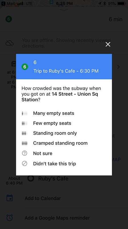
There are numerous ways in which Google Maps makes commuting easier. Besides being one of the best sources of information about any traffic congestions or blockages, Google Maps also helps users find a suitable ride in local train or subway. But unlike roads, Google’s algorithms or any GPS imaging cannot be used to judge the state of rush inside a train, which is why it is now seeking help from users and asking them how crowded is their train.
A number of users who use Google Maps to learn about the rapid transport routes in their cities have started to see a new dialog which is asking them about their train rides. It is now inviting users to answer if they see many vacant seats, only a few vacant seats, no vacant seats but ample space to stand, or no space such that they’re being crushed. We don’t see the information being broadcast for other users yet, which means this could be used to train Google’s prediction algorithms.
As per Android Police, iOS users have reported of seeing such prompts while taking the subway in places such as New York, San Francisco Bay Area, Washinton, Tokyo, and Paris for many months now. In addition, the feature has just started to appear on Android devices, with reports coming from Stockholm, Sweden and we have yet to see reports coming from other regions.


Last year, Google announced that it offers real-time data in Google Maps about any delays in public transport and trains for over 80 regions across the world. It also announced a partnership with the transport department of New South Wales, Australia, to alert commuters in Sydney about how crowded their train or bus could be. Back then, it said that the feature might come to other “cities around the globe” but now, it seems that it has decided to crowdfund this data instead of relying on government agencies or corporations.
To be able to use this feature, make sure you look up for train rides using Google Maps and keep GPS enabled so that your location can be ascertained with accuracy. There might be some glitches while using it underground due to limited or negligible GPS connectivity but we hope Google can find a way around that soon.
Update 1: Google Maps asks commuters about their bus rides too
As per a couple of our readers, similar alerts can be seen for designated bus routes in Buenos Aires, Argentina as well in Malta, Europe. The options are similar to what can be seen in the alerts for trains.


Thanks to Guillermo Joandet for this tip and screenshots.
Via: Android Police
Update 2: Official
Google has officially announced a couple of new features in Google Maps for people who rely on buses. As mentioned in the previous update, Google has been collecting data about the “crowdedness” of buses. They are now using that data to predict and show how crowded a bus will be before you get on it.
The next feature will give you live updates on the status of buses. Some transit agencies already provide this information, but for those that don’t, Google Maps will start showing estimated delay times for buses. You can even see where the delays are happening on the map.
These features will be rolling out to “nearly 200 cities” around the globe for both Android and iOS.
Source: Google
The post [Update: Official] Google Maps is asking some users how crowded their train rides are appeared first on xda-developers.


0 comments:
Post a Comment